After hiking Teapot Mountain Trail FOUR times, I've put everything I know about it into a blog post. You'll find how to get there, level of difficulty, best time to go, and more tips: https://www.sprinklehappiness.com/teapot-mountain/

Search
After hiking Teapot Mountain Trail FOUR times, I've put everything I know about it into a blog post. You'll find how to get there, level of difficulty, best time to go, and more tips: https://www.sprinklehappiness.com/teapot-mountain/
<用衛星圖找尋瀑布> 沒有人在照片裡,很難表現出比例尺。該瀑布20多公尺高,後面的懸崖更有100多公尺高以上。巨大的岩石和滑坡使照片中的一切看起來都微不足道,但是現場親眼目睹卻令人嘆為觀止。面對這座山,我們都很渺小。
🌊⛰🐢🤘
當我發現它時,也很難解釋我的感受。至少可以說這個瀑布很遙遠。即使在開始溪流溯溪之前,您也會失去網路信號。路線很長,坡度很高。每年的這個時候這個高度也很冷。當您知道有目的地在終點時,徒步旅行的時間就不會覺得那麼漫長了。但這是一條只有可能存在的東西還有很長的路要走。我的朋友無法繼續決定更早時間止步,所以我獨自走了最後800公尺。我不能保證我們實際上可以健行旅行到任何地方。有可能最後只是浪費力氣而已。
🌊
這就是在衛星照片上留下污跡的風險。最後可能甚至沒有大瀑布。路線未知,即使有,您也可能無法到達那裏。沒有其他訊息可以繼續下去,我甚至不知道它是否真實存在。但是,如果我到達那裡,那自然就在確認我的整個信仰體系。它是真實的。我並不瘋狂,而且它確實存在。這是最終的成就感。
⛰
http://tw.followxiaofei.com/taiwan/haomagaban-waterfall
Haomagaban Waterfall
Nantou County, Xinyi Township
郝馬戛班溪瀑布
南投縣信義鄉
GPS:
停車: 23.51846, 120.85389
瀑布: 23.50223, 120.86199
🐢
Without a person in the photo it's difficult to show a sense of scale. This waterfall is over 20 meters tall, and the cliff behind it goes up more than 100 meters. The sheer size of the rocks and the landslide make everything look miniature in photographs, but it's breathtaking to see in person. We are all very small when faced with the mountain.
🤘
It's also difficult to explain how I felt when I found it. This waterfall is remote to say the least. You'll lose mobile signal even before starting the river trace. The route is long, and the gradient high. This time of year it's also cold at this elevation. It's not such a long hike when you know there is a destination at the end. But it's a long way to go for something that only might exist. My team decided to stop earlier, so I went on the last 800 meters by myself. I couldn't guarantee that we were actually hiking to anywhere. It might just be a lot of effort for nothing.
🐢
That's the risk of following a smudge on a satellite photo. There might not actually even be a big waterfall at the end. The route is unknown, and you may not be able to reach it, even if there is. With no other information to go on, I don't even know if it's real until I make it. But if I do get there, then it's like nature is confirming my whole belief system. It's real. I'm not crazy, and it really does exist. This is the ultimate satisfaction.
---------------------------------------------------------------------
購買我設計的機能衣,也是支持我影片創作的收入
一直喜歡戶外走跳的我, 開著自己的露營車小阿卡, 穿梭在大自然裡找尋台灣漂亮景點
在溫泉~瀑布中~ 釋放自己, 完全回歸自然!
從尋尋覓覓 ,完成地圖, 改裝車子
我也親身測試體驗 更適合戶外的各項穿著
通過我的測試聯名好物 上架嘍~
小飛 / A-myzone 聯名品牌專業機能服
給一樣 愛戶外, 愛運動 的你們~
要溯溪游泳嚕石壁 耐磨抗水阻的水母衣 ?
曝曬爆汗 無法換洗 也不易發臭還抗菌 ?
跟著小飛玩 ~ 跟著小飛穿~
小飛的黑熊溯溪水母衣 (我最愛的一件) :https://a-myzone.com/product/detail/?d=237
小飛的黑熊Hiking多功能上衣 : https://a-myzone.com/product/detail/?d=240
小飛的上山下海溯溪水陸雙棲壓力褲(我最常穿的)
無痕速乾版 : https://a-myzone.com/product/detail/?d=245
護膝迷彩版 :https://a-myzone.com/product/detail/?d=247
小飛的輕便水陸兩棲快乾短褲 https://a-myzone.com/product/detail/?d=249
小飛的舒適登山露營外搭褲(我穿過最舒適的) https://a-myzone.com/product/detail/?d=247
跟著小飛玩
IG: https://www.instagram.com/followxiaofei/
FB: https://www.facebook.com/followxiaofei/
募資平臺贊助我的瀑布成癮症:https://www.patreon.com/xiaofei
YouTube: https://www.youtube.com/followxiaofei
地圖部落格:https://tw.followxiaofei.com/

For our weekly dose of greenery, we explored Chestnut Nature Park which is really a gem. Made up of 2 parts - Chestnut Nature Park (South) & Chestnut Nature Park (North), the park is actually Singapore’s largest nature park!
The North hiking trail is 3.5km long while the South trail is 2.1km long. You can easily complete the entire 5.6km in one day but we decided to go on the South trail first. That's because the terrain is more 'fun' to hike along - think stepping over tree logs, giant tree roots, boulders and climbing up stone steps. Nothing too overly challenging even for younger kids but good enough to excite them compared to a boring flat terrain. 😜
We love the rustic feels while trekking through the forested area - and we even saw more animals than we had seen on out previous hikes! Squirrels, swallows and even a wild boar family (4th photo)! The final part of the trail.brought us out into an open field of tall grass, which really felt like we were in a secret part of Singapore.
I think we will explore the North trail next... OR rent mountain bikes to take on the biking trail! That's becasue Chestnut Nature Park (South) is the first nature park in Singapore to have a separate mountain biking and hiking trail. And from what I saw of the many bikers there, the trails looks super fun!

#跑山獸 #搜救 #白姑大山 #台灣百岳 #三錐山 #SAR
如果您迷路,絕對不要往下到溪流或河谷
幾乎所有迷失的人最後找到的位置都是在河谷,他們走不出來
請求您們!
NEVER go down in stream or creek if you are lost.
All missing persons found in creek never walk out by themself.
PLEASE !
2021年09月19日
登山客白姑大山失蹤.搜尋手機訊號熱點區域認為他從三錐山南側稜線走失.失蹤者手機隔天早點4點20分可能沒電或走到收訊範圍外之區域無法再聯繫上...
19th September 2021
Hiker lost on the way down from BAIGU mountain in TAIWAN
By available information from cellphone reception we assumed he may turn to south ridge from SanZhui mt.
Victim's phone discharge or get out of reception next day at 4:20am, never call again...
@Beast Runners 跑山獸
by Petr Novotny
Subscribe, Like, Share this video to spread message about lost in mountains
Visit our eShop to support us: https://beast.run/shop/
♬♫ ♪ ♩
Music from Uppbeat (free for Creators!):
https://uppbeat.io/t/adi-goldstein/blank-light
License code: XFJEN1IC4ODXS9ZA
https://uppbeat.io/t/kisnou/name-of-the-night
License code: RTJLGU9YCALLJQ0F


此路線包含4座百岳,加利山、伊澤山、大霸尖山、小霸尖山,聖稜線端點之一,山勢磅礡奇特,而有「世紀奇峰」美譽,自古為泰雅、賽夏兩原住民族的聖山,外貌有如大酒桶,又稱「熬酒桶山」或「酒桶山」,與中央尖山、達芬尖山,合稱為「台灣三尖」。
這次行程比較可惜的一點是高山症發作以及下午天氣轉變,在時間考量下決定回程少走加利山、伊澤山,所以等我下次回來再來找你們囉!!
Mount Dabajian is located in the northern section of the Shei-Pa National Park in Hsinchu County, Taiwan. It is surrounded by numerous other peaks, the most predominant including Mount Nanhuda, Mount Yize, Central Range Point, Mt. Pintian, and Mt. Mutule. It is also near the Madala River.
【團隊類型】自組隊
🙋🏻 麗美、小艾、昶南、凱哥Farewell、文強、小蔓Mandy、金Jing、Shine
追蹤最新消息
➤ 𝗙𝗮𝗰𝗲𝗯𝗼𝗼𝗸
https://www.facebook.com/XieAerial
➤ 𝗜𝗻𝘀𝘁𝗮𝗴𝗿𝗮𝗺
https://www.instagram.com/xieaerial
▬▬▬▬▬▬▬▬▬▬▬▬▬▬▬▬▬▬▬▬▬▬
往下滑 ⏬查看
㊙️ 詳細路線資訊 ㊙️
🗺️ 【山岳資訊】 𝐌𝐨𝐮𝐧𝐭𝐚𝐢𝐧
⛰️ 大霸尖山 ' 海拔 3490 m
⛰️ 小霸尖山 ' 海拔 3418 m
⛰️ 伊澤山 ' 海拔 3297 m
⛰️ 加利山 ' 海拔 3112 m
📍 【路線定位點】𝗚𝗼𝗼𝗴𝗹𝗲 𝗺𝗮𝗽
✒️ 登山口/大霸尖山服務站 🌍 大鹿林道0.4K
https://goo.gl/maps/1MsQ5bLchvdLzDMW8
✒️ 東線瀑布 🌍 大鹿林道14.5K
https://goo.gl/maps/DbyHGB5pCFdhawSZA
✒️ 九九山莊 🌍 大霸尖山步道4K
https://goo.gl/maps/7hyoDMALXsaL48wSA
✒️ 加利山岔路/停機坪 🌍 大霸尖山步道6K
https://goo.gl/maps/qaQCmAvTfQTpDZbbA
✒️ 伊澤山岔路 🌍 大霸尖山步道8.8K
https://goo.gl/maps/QdKDdM71q8RikZcr5
✒️ 中霸坪 🌍 大霸尖山步道10.45K
https://goo.gl/maps/TXRquSVj8YdzQKQC8
✒️ 大霸尖山 ⛰️ 大霸尖山步道10.9K
https://goo.gl/maps/cGwZpFTX2bnv2kag7
✒️ 小霸尖山 ⛰️ 大霸尖山步道12K
https://goo.gl/maps/ypwZnBK9QfYLTW3D7
▬▬▬▬▬▬▬▬▬▬▬▬▬▬▬▬▬▬▬▬▬▬
🎛️ 【裝備列表】重裝15.1KG
⭕️【健行裝備】
登山包 | Natrehike 70L 1800g
攻頂包 | Natrehike 22L 摺疊包 180g
頭燈 | Naturehike 280lm 充電式 97.7g
登山杖 | Naturehike 碳鋁登山杖 185g
⭕️【穿戴衣物】
頭部 | 遮陽帽 ' 毛帽 (私物)
頸部 | 遮陽透氣脖圍 (攜帶沒使用)
手部 | 防寒手套(私物)
衣服 | 外層 | GoreTex
| 中層 | 刷毛衣
| 底層 | 運動排汗衫/UNIQLO Airism
褲子 | 運動短褲(外)壓力褲(內)
腳部 | 透氣運動襪 / MERRELL登山鞋
⭕️【 糧食】
溫水壺 | 容量1000cc / 裝滿 / 第二天裝熱水
水袋 | 容量2000cc / 實際攜帶1500cc
鹽糖 | 堅果巧克力 | 能量飲料 | 餅乾 | 乾燥飯 | 泡麵
⭕️【 救生裝備 】
鋁箔毯
扣環式指南針
哨子
緊急醫療包 ( 面速利達母 / OK繃 )
➤ 𝗙𝗮𝗰𝗲𝗯𝗼𝗼𝗸 粉絲團
https://www.facebook.com/XieAerial
➤ 𝗜𝗻𝘀𝘁𝗮𝗴𝗿𝗮𝗺
https://www.instagram.com/xieaerial
【 留言💬 訂閱🔔 點讚👍 分享🔗 】
協助演算法讓更多人看見我的辛苦作品🙏🙏
🌿 訂閱加小鈴鐺 🔔,有更新才會被通知。
🌿 歡迎實質課金支持我繼續創作的動力 🥰
➤ 𝑫𝒐𝒏𝒂𝒕𝒆 贊助我
https://p.ecpay.com.tw/80251
▬▬▬▬▬▬▬▬▬▬▬▬▬▬▬▬▬▬▬▬▬▬
➤ 0:00 開頭/前導 | Intro
➤ 1:30 0.4K 登山口/大霸尖山服務站 | Go
➤ 4:40 9.9K 石桌休憩點 | Resting stop
➤ 5:08 14.3K 東線瀑布 | Dong Sian Waterfall
➤ 5:35 17K捷徑 | Short Cut
➤ 6:17 19K工寮/午餐 | Resting stop/Lunch
➤ 7:30 19K50m 馬達拉溪吊橋 | Suspension bridge
➤ 8:03 0K 大霸登山步道口/馬達拉溪營地 |
➤ 8:52 4K 九九山莊/空拍/晚餐 | Villa/Drone/Dinner
➤ 9:42 回顧第一天路線 | Record Day 1
➤ 10:56 8.8K伊澤山岔路 | Forked road
➤ 11:49 10.9K大霸尖山 | Dabajian
➤ 12:41 12K小霸尖山 |
➤ 13:42 下山/結語 | End
#大小霸 #大霸群峰 #大霸尖山 @澎遊日誌【XieAerial】


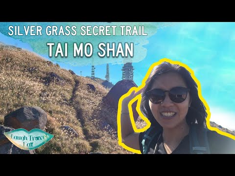
Tai Mo Shan is the highest mountain of Hong Kong and one of the best places to see silver grass. While you can go up and down on the concrete trail that is MacLehose Trail Stage 8, there's a hidden trail that takes you to the side of the highest point that's a silver grass heaven!
For the direction in an article:
Music by MBB
https://www.youtube.com/c/mbbmusic
https://soundcloud.com/mbbofficial
https://www.instagram.com/mbb_music
SOCIAL
Instagram - https://www.instagram.com/laughtraveleat/
Facebook - https://www.facebook.com/laughtraveleat/
USEFUL RESOURCES
Hiking essentials - https://bit.ly/2VT4AnU
Booking accommodations on holiday - https://bit.ly/35mOW7C
Planning a trip - https://bit.ly/2KOyW4H
Gear used:
Iphone 7 plus http://amzn.to/2eWHnxX
GoPro Hero 4 Silver http://amzn.to/2v6SVp3
GoPro tripod adaptor http://amzn.to/2eWGl5e
Gorilla Pod http://amzn.to/2uLsXop
DJI Spark Fly More Combo
http://amzn.to/2vTf1ec